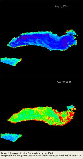
We are actively developing our research capabilities and expertise in the area of aquatic remote sensing, specifically in limnologic (inland or fresh water) and coastal remote sensing. Our main area of interest is the Great Lakes.
Encompassing nearly twenty percent of the world’s freshwater supply, the Great Lakes have long served multiple societal needs. Algal blooms have reappeared in the Great Lakes with greater frequency and intensity in recent years. Moreover, the possibility of toxin producing strains can lead to significant water management issues. As part of the MERHAB (Monitoring and Event Response for Harmful Algal Blooms) project, we are exploring the utility of chlorophyll extraction techniques to map the spatial and temporal variations in algal blooms in Lake Erie and Lake Ontario.
Remote sensing is coupled with in-situ measurements of algal concentrations (chlorophyll-a) in Lakes Erie and Ontario, and the images also are used with predictions from a hydrodynamic and particle tracking model to determine transport pathways. The project goal is to develop a system that uses remote sensing to identify the formation of a bloom and can predict the movement of the bloom through modeling.
We have tested a variety of the existing models to produce Chlorophyll products for the lower great lakes. Preliminary results show that Carder’s Algorithm (Carder, 1999), deployed in SeaDAS provides the most reliable numeric values for Lake Erie and Lake Ontario.
In addition, we are developing an algorithm to determine the abundance of Phycocyanin in Lake Erie and Lake Ontario, to help delineate potentially harmful algal blooms.
Links to MERHAB LGL groups:
Greg Boyer, SUNY – College of Environmental Science and Forestry
Joseph Atkinson, SUNY- University at Buffalo
Joseph Makarewicz, SUNY Brockport
Mary Watzin, University of Vermont
Steve Wilhelm, University of Tennessee