We are proposing to investigate the paleo-hydrologic setting of the previous wet climatic periods across the Empty Quarter. This will be enabled through the integration of observations collected in the field and others extracted from remotely acquired data including: (1) distribution of paleolakes from Landsat images, (2) distribution of paleo-stream networks from radar images, and (3) examining the morphological characteristics indicative of areas of groundwater discharge (sapping features).
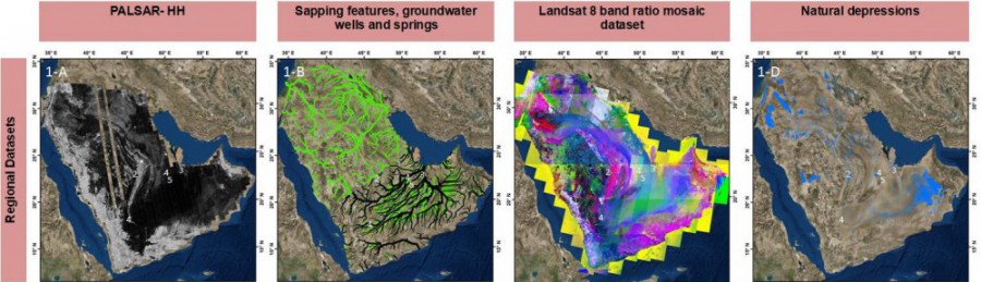
1A : ALOS PALSAR radar backscatter coefficient mosaic (12.5 m) over Arabian Peninsula. 1B: Drainage networks based on recent topography (green) and topography before sand dune encroachments (black). The dune free topography was derived from interdunal elevation values. 1C: Landsat 8 band ratio color composite for identification of lake deposits; Red: SWIR1/SWIR2, Green: NIR/SWIR1, Blue: NIR/Red 1 D: Natural depressions derived from DEM.
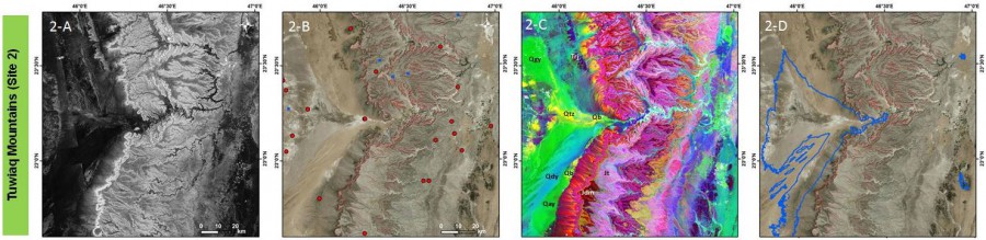
2 A: PALSAR coverage over Tuwiaq Mountains and wadi showing plaeochannels and escapements. Relatively brighter lake deposits correlate with band ratio images (2-C) and depression map (2-D). 2B: Satellite imagery over Lake Umm Athelah with ground water well (red circles) and spring locations (blue squares). Sapping features (red pixel elements) and springs are aligned with escarpments and correlate with onset of lake deposits. 2C: Band ratio image showing different lithological units including; Qtz:Vadi bed deposits, Qb: Evaporites, Qgy: Gravel, Qay: Gravel, sand silt, Qdy: Eolian sand, Jt: Limestone, Jdm:Sandstone, TrJ: Marl. Claystone, sanstone 2D: Depression map delineates the previous lake formations.